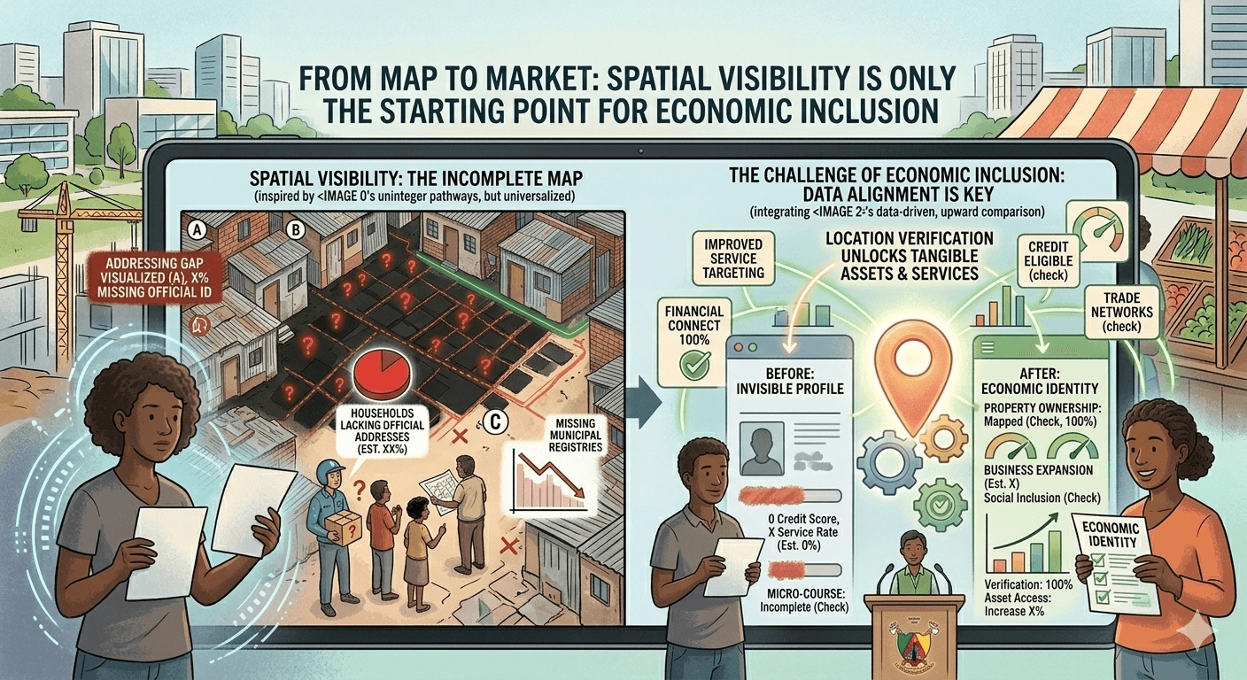
From Map to Market: Why Spatial Visibility Does Not Equal Economic Inclusion
Bridging that gap demands attention not merely to where buildings stand—but to how location is institutionally defined, standardized, and shared.
Introduction: The Illusion of Being Seen
In the 21st century, almost every inhabited place on Earth is visible from space. High-resolution satellite imagery, digital mapping platforms, and GPS-enabled devices have created an unprecedented level of spatial visibility.
From a cartographic perspective, the world appears mapped.
Yet spatial visibility does not automatically translate into economic inclusion.
A neighborhood may be visible on a digital map and still remain functionally excluded from credit systems, insurance markets, formal logistics networks, and public investment pipelines.
The difference between being mapped and being economically integrated lies in the structure of location recognition.
The Mapping Revolution
Over the past two decades, advances in geospatial technologies have transformed global mapping. Platforms powered by satellite imagery and crowd-sourced data have dramatically expanded geographic coverage.
Organizations such as the United Nations and the World Bank increasingly rely on geospatial data to inform development planning, disaster response, and infrastructure investment.
In humanitarian contexts, mapping has improved crisis coordination. In urban planning, it has supported transport modeling and environmental monitoring.
Visibility has improved.
But mapping is not the same as market integration.
Coordinates Are Not Addresses
A geographic coordinate can identify a point on the Earth’s surface with extraordinary precision. However, coordinates alone do not function as socially or institutionally interoperable identifiers.
Markets require:
- Place-to-Person Identification
- Recognizable formats
- Standardized registries
- Persistent references
- Cross-institutional acceptance
An address is not merely a location. It is a shared institutional language for location.
A set of coordinates may tell a satellite where a building stands. It does not necessarily tell a bank how to verify residence, a utility how to bill a household, or a court how to establish jurisdiction.
Economic systems require more than spatial accuracy—they require structured location identity.
Informal Settlements: Visible but Marginalized
UN-Habitat estimates that over one billion people live in informal settlements worldwide. Many of these communities are fully visible on satellite imagery.
They are mapped. They are counted in broad demographic surveys. They appear on navigation platforms.
Yet residents may still face:
- Difficulty opening bank accounts
- Challenges obtaining insurance
- Barriers registering businesses
- Inconsistent utility services
Spatial visibility does not automatically confer institutional recognition.
Without standardized, household-level address frameworks, economic systems may continue to treat these areas as ambiguous zones.
Financial Systems and Location Verification
Financial institutions operate within regulatory frameworks shaped by anti-money laundering standards and risk management protocols. Bodies such as the Financial Action Task Force encourage robust verification processes, including confirmation of residential address.
"A satellite image of a building does not satisfy compliance requirements" ~ Ndamo Ndamo (Founder/Visionary at Addrezza).
Banks require:
- Verifiable documentation
- Recognized address formats
- Accurate residential identity
- Consistency across records
If a neighborhood lacks standardized address references integrated into national registries, mapping alone does not enable financial inclusion.
The World Bank’s Global Findex data repeatedly shows that documentation barriers contribute to persistent unbanked populations. Address instability is often embedded within those barriers.
Logistics and the Limits of Digital Maps
E-commerce and delivery platforms rely heavily on digital mapping. Yet last-mile delivery failures remain common in areas with ambiguous or inconsistent addressing.
Even when drivers can navigate to a neighborhood via GPS:
- Identifying the correct household may require phone calls
- Building subdivisions may be unclear
- Numbering systems may not match map entries
Recent reports from the World Economic Forum (WEF), in collaboration with Accenture, highlight that rapid e-commerce growth is placing unsustainable pressure on urban infrastructure, with last-mile delivery inefficiencies expected to increase by 2030. Without intervention, urban delivery vehicles are projected to increase by 36%, leading to higher emissions and severe congestion.
Mapping supports navigation. Address systems support precision.
Key Last-Mile Delivery Inefficiencies & Impacts (WEF Highlights)
- Surging Demand and Congestion: Urban last-mile delivery emissions are set to rise by over 30% by 2030, with congestion causing an extra 11 minutes in daily commutes for residents.
- Failed Deliveries and Inefficiency: Inefficient, traditional, to-door delivery methods result in high rates of failed, first-attempt deliveries, necessitating costly re-deliveries.
- Infrastructure Strain: Urban areas face limited space for essential infrastructure like electric vehicle (EV) charging and parcel lockers, resulting in increased double-parking and blocked, safe walkways.
- Cost and Environmental Impact: Last-mile delivery makes up a substantial portion of shipping costs, often accounting for 53% of the total. Increased, unoptimized traffic leads to higher carbon emissions and reduced air quality, negatively impacting public health.
- Operational Challenges: Drivers are wasting time searching for parking, with commercial vehicles in some cities spending up to 28% of their trip time looking for spots
The difference influences cost, reliability, and scalability.
Public Investment and Data Granularity
Governments increasingly use spatial data to allocate resources. However, broad geographic visibility does not guarantee granular household-level data.
Effective targeting of:
- Social protection programs
- Utility expansions
- Education infrastructure
- Public health interventions
requires more than neighborhood-level mapping.
It requires precise identification of individual economic units.
The OECD’s research on evidence-based policymaking underscores the importance of high-quality administrative data. Address precision strengthens that data.
Without it, policy operates at coarse resolution.
Property Rights and Market Confidence
Land and property markets depend on clear, enforceable location references.
A visible structure on a satellite image does not equate to:
- Registered parcel boundaries
- Recognized street numbers
- Legal address documentation
Property markets require standardized referencing to enable:
- Title registration
- Mortgage lending
- Insurance underwritingTransaction transparency
Where addressing systems lag behind physical development, real estate markets may remain partially informal or undercapitalized.
Spatial visibility without institutional integration limits asset formalization.
Digital Public Infrastructure and Interoperability
Many countries are investing in digital public infrastructure frameworks, integrating identity, payments, and data exchange systems.
However, interoperability depends on consistent reference points across systems.
If location data remains fragmented or non-standardized:
- Identity records may not align with residence records
- Tax systems may not align with utility databases
- Social registries may not synchronize with municipal records
The World Bank’s digital government initiatives emphasize that foundational registries must function cohesively.
Mapping improves awareness. Address systems enable integration.
Climate Risk and Geographic Targeting
Climate adaptation strategies increasingly rely on granular spatial data. Flood zones, wildfire risk areas, and heat vulnerability mapping require precise household-level referencing.
Being visible on a climate map does not ensure:
- Timely evacuation notices
- Insurance coverage
- Infrastructure reinforcement
Address precision determines whether interventions can be targeted effectively.
Without structured household referencing, risk mitigation remains generalized rather than precise.
Developed Economies and Hidden Gaps
Even in advanced economies with mature mapping systems, spatial visibility does not eliminate addressing challenges.
High-density rental markets, informal subletting, and rapid suburban development can create mismatches between mapped structures and officially recognized addresses.
As economies digitize further, reliance on precise location verification increases.
The gap between mapping and institutional integration can persist even in technologically advanced contexts.
From Visibility to Recognition
Visibility answers: Where is it?
Recognition answers: What is it within institutional systems?
Markets operate on recognition.
They require:
- Stable identifiers
- Persistent records
- Cross-sector acceptance
- Legal grounding
Spatial visibility without institutional recognition produces a false sense of integration.
Communities may appear connected on a map yet remain excluded from full economic participation.
Conclusion: Seeing Is Not Structuring
The mapping revolution has made the world visually legible.
But economic inclusion requires more than visual legibility.
It requires structured, interoperable, and persistent location systems that connect households to markets, institutions, and governance frameworks.
Being on the map is not the same as being in the market.
Bridging that gap demands attention not merely to where buildings stand—but to how location is institutionally defined, standardized, and shared.
Only then does visibility translate into opportunity.