The Economic Geography of Opportunity: How Address Precision Shapes Mobility
In an era defined by urbanization, digitization, and data-driven governance, address precision becomes a quiet but powerful determinant of economic geography.
Introduction: Geography Is Not Neutral
Economic opportunity is not evenly distributed. It clusters.
Jobs concentrate in cities. Credit flows through recognized financial districts. Infrastructure expands where planning data supports investment. Public services are deployed where administrative records confirm demand.
Geography shapes opportunity—but geography is only as actionable as it is legible.
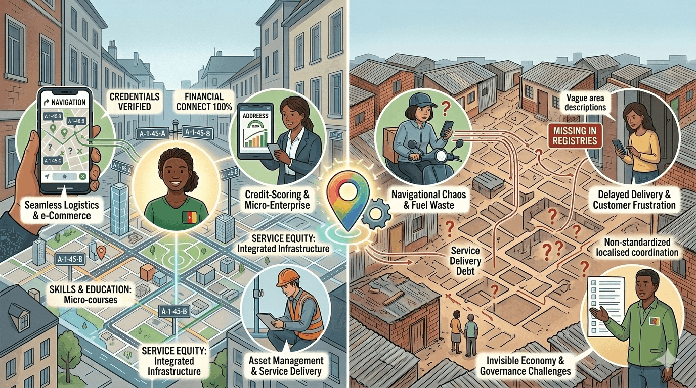
An economy may know where growth is happening in broad terms. But if it cannot precisely reference households within that geography, mobility becomes constrained not only by income or education, but by infrastructure invisibility.
Address precision plays a subtle yet decisive role in shaping who can move upward—and who remains administratively peripheral.
Location as an Economic Variable
Economists have long studied spatial inequality. Research from the World Bank and the OECD consistently shows that where a person lives significantly influences income trajectories, access to public goods, and exposure to risk.
Location determines:
- Commute distance to employment centers
- Proximity to schools and hospitals
- Exposure to environmental hazards
- Access to transportation networks
- Verification and Identification
- Access to global opportunities & markets
But beyond physical proximity lies administrative proximity.
When households are precisely recognized in institutional systems, they are more easily:
- Served
- Credited
- Insured
- Counted
Imprecise location data introduces friction into each of these interactions.
Mobility and the “Proof of Residence” Barrier
Economic mobility often requires movement—rural to urban migration, relocation for employment, transition from informal to formal housing.
However, upward mobility frequently triggers documentation requirements:
- Accessing credit and capital
- Registering for utilities
- Signing a formal lease
- Enrolling children in school
Proof of address becomes a recurring checkpoint.
World Bank Global Findex data highlights documentation barriers as a major reason adults remain outside formal financial systems. While identification gaps are frequently discussed, address instability is a parallel constraint—especially for renters and migrants.
If residential recognition lags behind physical relocation, mobility slows.
Urbanization Without Administrative Integration
The United Nations projects that nearly 68 percent of the global population will live in urban areas by 2050. Much of this growth is occurring in Africa and South Asia.
Urban expansion often outpaces:
- Formal planning
- Parcel registration
- Address standardization
UN-Habitat reports that informal settlements continue to house a substantial share of urban residents globally.
In such contexts, economic mobility becomes spatially paradoxical. Cities offer opportunity—but administrative recognition may remain incomplete.
Without precise household-level referencing:
- Rental histories are difficult to document
- Service continuity is disrupted
- Geographic data undercounts demand
- Urban opportunity requires administrative legibility.
- Credit Access and Geographic Risk
Financial institutions rely on geographic data to evaluate risk.
Location influences:
- Property valuation
- Exposure to climate events
- Crime statistics
- Infrastructure reliability
Insurance premiums and lending terms often reflect spatial modeling.
If address systems lack granularity or consistency:
- Risk modeling becomes less precise
- Institutions compensate with higher premiums or stricter requirements
- Borrowers in under-documented areas face disadvantage
OECD research on financial inclusion emphasizes that data asymmetries increase exclusion.
Address precision reduces asymmetry.
Labor Markets and Platform Economies
Digital labor platforms—ride-hailing, delivery, freelance services—depend on reliable location data.
Precise addressing improves:
- Worker onboarding
- Service routing efficiency
- Performance tracking
- Dispute resolution
When workers operate in areas with ambiguous addressing:
- Earnings may decline due to routing inefficiencies
- Platform trust mechanisms weaken
- Customer friction increases
Location precision therefore influences income stability within platform-based economies.
Public Investment and Spatial Data Quality
Governments allocate infrastructure investment based on demographic and geographic data.
If households are inaccurately referenced:
- Census data may misrepresent density
- Utility demand projections may understate need
- School and clinic placement may lag behind actual population growth
The OECD has repeatedly emphasized the importance of data-driven policymaking. But data quality depends on foundational geographic systems.
Imprecise addressing distorts investment decisions, reinforcing spatial inequality.
Climate Risk and Geographic Vulnerability
Climate change introduces new layers of spatial risk:
- Flood plains
- Coastal erosion zones
- Heat vulnerability areas
Effective adaptation and insurance planning require granular location data.
Without precise household-level referencing:
- Disaster response targeting weakens
- Insurance penetration remains uneven
- Vulnerable populations become harder to support
The World Bank’s climate resilience programs underscore the importance of spatial data infrastructure in mitigation planning.
Address precision strengthens resilience.
Rental Economies and Vertical Mobility
As urban housing markets densify, rental arrangements become more complex.
High-rise buildings and subdivided structures house multiple economic units.
If administrative systems recognize only building-level addresses:
- Individual renters lack distinct recognition
- Credit histories blur
- Service records aggregate inaccurately
Economic mobility increasingly occurs within rental markets. Address systems must reflect this reality to support upward movement.
The Feedback Loop of Legibility
Administrative legibility influences economic trajectory through a reinforcing loop:
Precise addressing improves service access.
Improved service access enhances productivity.
Productivity supports income growth.
Income growth strengthens formal participation.
Conversely:
- Imprecise addressing limits access.
- Limited access suppresses opportunity.
- Suppressed opportunity reinforces marginalization.
- Infrastructure invisibility compounds inequality.
Developed Economies Are Not Immune
Address precision challenges are not confined to developing contexts.
In advanced economies:
- Informal subdivisions occur in high-cost cities.
- Migrant populations face documentation instability.
Rapid suburban expansion introduces inconsistencies.
Even where baseline systems are strong, rental churn and urban complexity introduce gaps.
Economic geography evolves faster than legacy address frameworks.
Interoperability and Opportunity
The future of digital public infrastructure increasingly depends on interoperability across identity, finance, land, and service systems.
Location is a shared reference point.
If address systems are:
- Persistent
- Standardized
- Machine-readable
- Recognized across institutions
Then economic mobility benefits from reduced friction.
If not, opportunity remains geographically uneven.
Conclusion: Legibility as Equity
Economic geography shapes life outcomes. But geography becomes actionable only when it is legible to institutions.
Address precision does not create opportunity on its own. Roads, education, and capital investment remain essential.
However, without precise location infrastructure, the benefits of those investments distribute unevenly.
Mobility depends not only on where people live—but on whether where they live is structurally recognized.
In an era defined by urbanization, digitization, and data-driven governance, address precision becomes a quiet but powerful determinant of economic geography.
The map matters.
And so does how precisely it recognizes each household upon it.